
phillifan22
-
Posts
96 -
Joined
-
Last visited
Content Type
Profiles
Forums
Hunting New York - NY Hunting, Deer, Bow Hunting, Fishing, Trapping, Predator News and Forums
Media Demo
Links
Calendar
Store
Everything posted by phillifan22
-
Yeah that’s not surprising. Albany NWS just upgraded the area from winter wx advisory to winter storm warning. So their confidence is increasing in higher snowfall. Based on that, as well as what I’ve looked at, I would expect around 8”. The reason for the spread in forecasts from people is that the precip type may change to sleet at times early Friday morning, lowering the totals from 8” to 4”. And contrary to that, some models have it staying all snow, leading to 10” or more. It’s impossible to say if 4” or 10” is more likely, but I’m personally leaning towards the higher end. The bigger issue for where you set up is that I think the warmer temperatures Friday afternoon and overnight into Saturday morning (plus the still-warm-ground and consistent winds) will lead to a lot of melting and compaction. So if you get 4” of snow from this storm, you might only have 1” by sunrise Saturday. If you get 10” Friday, you might only have 4-5” by sunrise Saturday. Hope this helps. Sent from my iPhone using Tapatalk
-
Looks like 2-4” of sloppy wet snow and sleet for this storm down there, so I’d imagine by Saturday there’s only an inch or less left cause it will be above 32F after like 7am Friday all the way through Saturday night. However, the highest elevations of those units they might hold on to like 3” of snow if they stay cooler. Im not sure what that will do to deer movement but I’d imagine it won’t impact them much for Saturday/Sunday. Sent from my iPhone using Tapatalk
-
any one else excited about snow opening day of firearms as I
phillifan22 replied to rob-c's topic in General Chit Chat
Wet and heavy. Sent from my iPhone using Tapatalk -
any one else excited about snow opening day of firearms as I
phillifan22 replied to rob-c's topic in General Chit Chat
I would be excited but I’m starting to get a bit nervous about the snow being very compact and wet Friday afternoon as temps go above freezing, before dropping near or just below freezing Saturday morning. So wet and maybe crunchy. Sent from my iPhone using Tapatalk -
Here are the three NWS offices current forecasts. They look very reasonable to me. Could be a sharp NW cutoff for this storm, so areas in WNY may see less snow than this. Also, areas east of I-88, and south of Albany along I-87 may see less snow due to warm air aloft nosing in to SE NY and leading to sleet or freezing rain instead of snow. Another thing to note is that temperatures will warm on Friday during the afternoon into the upper 30s, leading to melting and compaction of this fresh snow. With temperatures then falling to at or below freezing overnight into Saturday morning, it could be a crunchy walk in, and wet sit for Saturday morning.
-
Yup. Anywhere from Albany and south near the Hudson is really tricky for snow forecasts for this storm. Some warm air aloft might come up and change the precip to sleet or freezing rain rather than snow. Sent from my iPhone using Tapatalk
-
Update - 11/14 for 11/17 Alrighty, we have lake effect winding down today, giving some places some nice fresh snow for hunting today and tomorrow. The next system will be moving into NY Thursday evening, moving out Friday night. This system is very tricky due to models being all over the place with precip-type, however, it currently looks like most of WNY, CNY, S Tier, Catskills, and even the Capital Region will get several inches of snow Thursday night into Friday. Totals will likely be around 4-7", but up to 10" is possible. Some models only have 2-3" of snow, with more of it falling as sleet or freezing rain. The issue for a lot of places will be that the snow could turn to rain by mid-day Friday, compacting all the fresh snow. So, with the system moving out Friday night, opening day will be much calmer with pressure rising. Most of the SZ will have a few to several inches of fresh fluffy or compacted snow on the ground already. Temps will likely start out in the mid-upper 20s or low 30s, becoming upper 30s or low 40s by mid-day, and back into the mid-30s by sunset. Winds are expected to generally be out of the W/SW across the state throughout the day. Wind speed will start out higher in the early morning (10-15mph), but gradually drop to 5-10mph by mid-day and for the afternoon hunt. Skies will generally be partly to mostly cloudy with a few breaks of sun. There is a chance of lake effect rain or snow showers E of Lake Ontario across the Tug, with the threat possibly drifting down across Oneida/Madison counties during the afternoon. There is also that threat of lake effect rain or snow showers E/SE of Lake Erie extending into the Genesee Valley and Finger Lakes region throughout the day. I hope to send out more updates tomorrow or Friday, but it looks like a decent opening day!
-
LIVE From The Woods 2018 - Lets hear stories and see some pictures!
phillifan22 replied to burmjohn's topic in Deer Hunting
Well, it’s looking more likely there will be a snow storm tmrw night into Friday for the STier, CNY, Catskills, and maybe capital region. So opening day could have some fresh snow! I’ll post a more detailed update in the other thread. Sent from my iPhone using Tapatalk -
LIVE From The Woods 2018 - Lets hear stories and see some pictures!
phillifan22 replied to burmjohn's topic in Deer Hunting
Well this wasn’t here yesterday Sent from my iPhone using Tapatalk- 10374 replies
-
- 6
-

-
- bow hunting
- deer hunting
- (and 4 more)
-
LIVE From The Woods 2018 - Lets hear stories and see some pictures!
phillifan22 replied to burmjohn's topic in Deer Hunting
That is a fat rutted neck. Sent from my iPhone using Tapatalk -
Damn you got me....[emoji58] Sent from my iPhone using Tapatalk
-
LIVE From The Woods 2018 - Lets hear stories and see some pictures!
phillifan22 replied to burmjohn's topic in Deer Hunting
Forgot to post this yesterday....saw a big buck chase and breed a doe at about 150 yds...at 1:03pm. Guess mid-day hunting ain’t so bad. Sent from my iPhone using Tapatalk- 10374 replies
-
- 2
-
-
- bow hunting
- deer hunting
- (and 4 more)
-
LIVE From The Woods 2018 - Lets hear stories and see some pictures!
phillifan22 replied to burmjohn's topic in Deer Hunting
Congrats! Guess there was adeerthere Sent from my iPhone using Tapatalk -
Update - 11/12 for 11/17 I didn't post an update again last week because the forecast hadn't changed much, but I figured with opening day only being 5 days away I should send another update. So, for the final 5 days of bow, we have a nice day today (Mon), a coastal storm resulting in gross mixed precip (starting as snow changing to rain) on Tuesday, windy and cold across NY with lake effect snow E/SE of the lakes Wednesday, before a beautiful calm and sunny (but cold) day on Thursday. Friday another coastal storm/low pressure system will lead to more gross snow and mixed precip and gusty winds across NY. This leads us into Saturday, where the models are actually in decent agreement, but things can still change. Generally, things will be calming down as the low pressure system from Friday exits the area, leading to rising/increasing pressure. Temps will start out in the upper 20s/low 30s, warming into the upper 30s by mid-day. Wind direction looks to generally be out of the W/WSW throughout the day. Wind speed around 10-12mph for the morning, weakening to 5-10mph for mid-day, afternoon, and evening. Skies will be partly to mostly cloudy with some sun at times. Also, there will be a chance for some light/weak lake effect snow (or even rain) showers throughout the day in the usual areas (I'll be able to give more specific timing/location details on this as we get closer to Saturday). Stay tuned for more updates! Hope we see some action in the harvest and live woods threads during the last week of bow!
-
LIVE From The Woods 2018 - Lets hear stories and see some pictures!
phillifan22 replied to burmjohn's topic in Deer Hunting
I think I saw a study where deer movement and wind correlate positively (calm winds = less movement, higher winds = more movement). But there must be a wind speed where their movement slows? Maybe 30mph? Sent from my iPhone using Tapatalk -
LIVE From The Woods 2018 - Lets hear stories and see some pictures!
phillifan22 replied to burmjohn's topic in Deer Hunting
Congrats Culvercreek! Weird to say cause my last name is Culver and it’s pretty rare! Maybe this Culver can get a nice buck like that soon! Sent from my iPhone using Tapatalk- 10374 replies
-
- 2
-
-
- bow hunting
- deer hunting
- (and 4 more)
-
LIVE From The Woods 2018 - Lets hear stories and see some pictures!
phillifan22 replied to burmjohn's topic in Deer Hunting
I’m going to guess you live south/SE of Buffalo? Or east of Lake Ontario? Sent from my iPhone using Tapatalk- 10374 replies
-
- 1
-
-
- bow hunting
- deer hunting
- (and 4 more)
-
LIVE From The Woods 2018 - Lets hear stories and see some pictures!
phillifan22 replied to burmjohn's topic in Deer Hunting
Had the wife check me [emoji6], didn’t find anything. Guess that Sawyers stuff worked pretty well this time. Sent from my iPhone using Tapatalk- 10374 replies
-
- 1
-
-
- bow hunting
- deer hunting
- (and 4 more)
-
LIVE From The Woods 2018 - Lets hear stories and see some pictures!
phillifan22 replied to burmjohn's topic in Deer Hunting
Naturally I go to post and a doe being chased by a 4pt sprint past me 5ft away...can’t hear anything in this loud rain Sent from my iPhone using Tapatalk- 10374 replies
-
- 1
-
-
- bow hunting
- deer hunting
- (and 4 more)
-
LIVE From The Woods 2018 - Lets hear stories and see some pictures!
phillifan22 replied to burmjohn's topic in Deer Hunting
Spooked a spike on my way in. Deep in the heart of the pine bush in the rain... #ontheground Sent from my iPhone using Tapatalk- 10374 replies
-
- 4
-
-
- bow hunting
- deer hunting
- (and 4 more)
-
LIVE From The Woods 2018 - Lets hear stories and see some pictures!
phillifan22 replied to burmjohn's topic in Deer Hunting
Feels very deery out this morning, with some frost too. Saw a lot of hunters around the pine bush so I’m expecting a lot of action on here this morning... Sent from my iPhone using Tapatalk- 10374 replies
-
- 2
-
-
- bow hunting
- deer hunting
- (and 4 more)
-
Yeah it’s a definite shooter for us too. Bigger than anything we’ve got the last few years Sent from my iPhone using Tapatalk
-
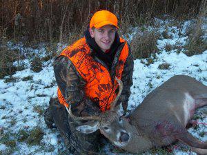
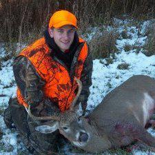
Crappy pics, but my pops just sent me these for where we are hunting opening day of gun. Very tall rack. Sent from my iPhone using Tapatalk
-
LIVE From The Woods 2018 - Lets hear stories and see some pictures!
phillifan22 replied to burmjohn's topic in Deer Hunting
I’m always fascinated with what I picture people to look like on here and what they actually look like. Usually wrong Sent from my iPhone using Tapatalk- 10374 replies
-
- 2
-
-
- bow hunting
- deer hunting
- (and 4 more)
-
I get that all the time when I tell people what I do! But surprisingly, if you are wrong over 50% of the time you get canned Sent from my iPhone using Tapatalk
